Holding the Green Line
Conservation at the Climate Frontline in Central African Republic
From the air, the trees appear infinite.
Thirty, forty, fifty minutes of flight over unbroken green. The canopy rolls past like a vast, breathing ocean - dense, textured, alive with variation. Rivers cut silver through the woodland. No roads interrupt the pattern. No villages punctuate the green. For all the evidence your eyes can gather, this wilderness could stretch to the edge of the world.
This is northern Central African Republic, where over 115,000 square kilometers of Sudano-Sahelian woodland span 18% of the entire country. Known as the Northeastern Protected Area Complex, this interconnected system encompasses two national parks – Manovo-Gounda St. Floris and Bamingui-Bangoran – along with wildlife reserves and wildlife corridors that together form one of the last major unfragmented forests in the transition zone between Africa's desert and its equatorial heart.
You head slightly further north, and the contrast is stark. The green thins, becomes patchy, gives way to beige. Livestock trails score the earth. The signs of pressure are everywhere: people vying for diminishing resources, lives adapted to scarcity, a landscape transformed by the realities that define the Sahel today — erratic weather, unpredictable seasons, conflict over resources.
The endless green you just flew over isn't just wilderness. It's what's holding the line between the Sahara and the critical forestland in Central Africa’s interior.
The Continental Climate Barrier
Across the Sahel, the green belt of woodland and savanna that separates desert from equatorial forest is fragmenting. Pressures that have already displaced 800,000 people continue to mount.
Manovo-Gounda and Bamingui-Bangoran sit at perhaps the most critical juncture in this belt. To the north lies the advancing Sahara. Five hundred kilometres to the south: the Congo Basin, the continent's great tropical forest, second in size only to the Amazon. Between them, this landscape is one of the last intact pieces of the transition zone — the living barrier that keeps Central Africa's equatorial forests from being surrounded by desert.
The rivers flowing through this landscape — the Aouk, the Bahr Aouk, their tributaries — originate here and flow north into the Lake Chad Basin. Forty million people depend on them. This forest is a continental water tower: roots filter and store moisture, the canopy captures rainfall, and seasonal flows regulate water for millions living downstream in one of the world's most water-stressed regions.
If the transition zone breaks here — between the Sahara's advance from the north and the Congo Basin to the south — the consequences ripple across systems. Forty million people lose access to reliable water. The Congo Basin loses its buffer zone, becoming vulnerable to the same fragmentation. Climate refugees displaced from the Sahel have fewer places left to move. The green belt that moderates Africa's climate snaps at one of its weakest points.
An Empty Forest
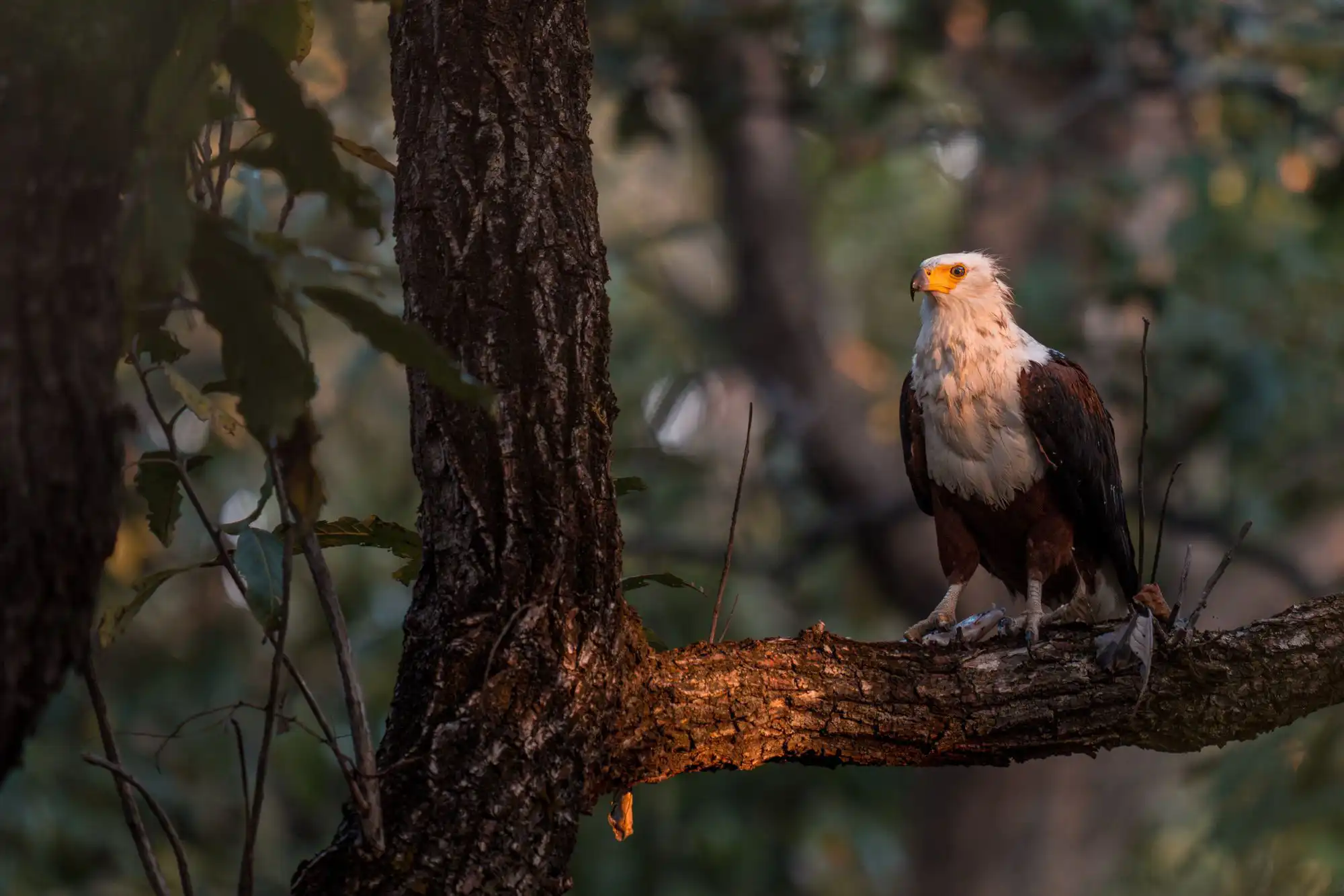
Forty years ago, thousands of elephants moved through these woodlands. Lions hunted in healthy prides. Giraffes browsed the canopy. Buffalo herds numbered in the tens of thousands. Giant eland - some of the largest antelope specimens ever recorded - thrived here alongside wild dogs, hippos, and forest buffalo.
Today, you might find an elephant’s footprint, but the elephant itself has become a ghost. A dozen, perhaps, remain; possibly fewer. Lions exist in scattered remnants. The charismatic megafauna that define functional African ecosystems have been vastly reduced.
The forest itself was never the problem; it remains remarkably intact. The animals vanished from within it. Decades of commercial poaching stripped the landscape of its wildlife. And then, most likely, disease did the rest: a cattle-borne epidemic that killed off half the ungulate population in a landscape where livestock and wildlife share the same shrinking water sources.
The parks existed on paper — Manovo-Gounda St. Floris established in 1979, a UNESCO World Heritage Site by 1988 — but the conditions that make protection possible didn't yet exist. Roads hadn't reached this territory. Security institutions hadn't extended this far. Armed poachers crossed the border from Sudan on horseback hunting ivory, and in a landscape this remote, this ungoverned, no organisation could stop them alone. Isolation and instability meant that no sustained protection was possible.
%20copy.webp)
%20copy.webp)

Understanding why wildlife loss affects ecosystem health—even when the trees remain standing—requires understanding how ecosystems function as climate barriers. Elephants moving across vast distances disperse seeds that maintain forest composition and enable regeneration. Herbivores create the mosaic of habitats that prevents any single species from dominating while allowing vegetation to recover. Predators regulate populations, maintaining the balance that prevents overgrazing. Remove these animals, and the trees remain standing — but the ecosystem loses the capacity to regulate itself, to withstand drought, to capture and store water, and to anchor soil.
Pressure at the Frontline
Each dry season, the complexity arrives on the horizon as dust. Cattle herds approach the park’s edges — hundreds, sometimes 2,000 animals, moving with the seasons from Chad and Sudan. The herders follow ancient routes, crossing borders in search of grass and water. The landscape they share with 120,000 permanent residents is one where governance has historically been weak, and where climate change is accelerating the pressures.
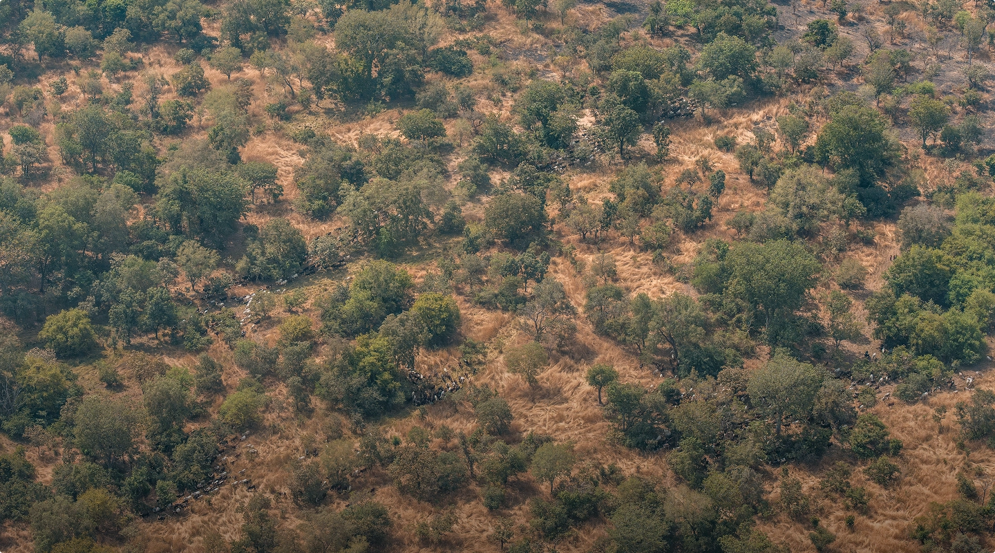
This is transhumance — seasonal livestock migration that has shaped the Sahel for centuries.
Where animals once moved through a landscape with enough water for all, climate stress is now crowding wildlife and livestock together at shrinking sources. The consequences run in both directions: disease transmission that threatens the recovering wildlife populations, but also the cattle herds families depend on — and ultimately the water quality flowing north to millions downstream.
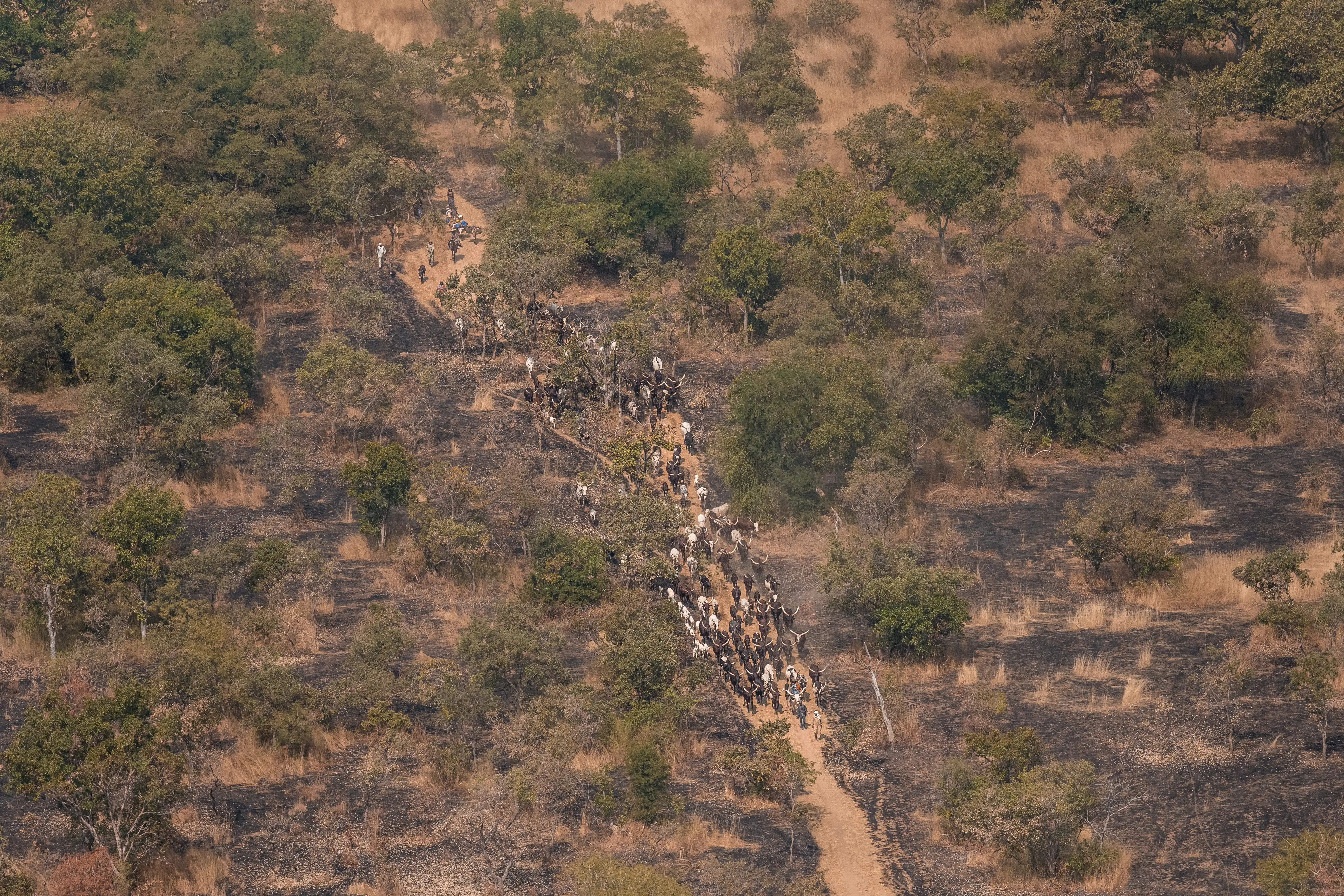
And commercial interests have captured this traditional practice. Armed groups control illegal mining. Criminal networks claim ungoverned spaces and predate on traditional herders. Mercenaries operating in the region accumulate thousands of cattle as mobile wealth. This is one of the world's most fragile states, and the government has a minimal presence in the northern territories where these parks are located.
In a landscape where cattle and wildlife share the same shrinking water sources — and where those waters flow north to 40 million people — the health of livestock, wildlife, and people cannot be managed independently. A disease outbreak in a cattle herd can devastate a recovering wildlife population. A recovering wildlife population can stabilise the watershed a cattle herd depends on.
These converging pressures make northern CAR one of the most challenging conservation environments on Earth. But the stakes are equally immense: this transition zone is where the green belt holds or breaks.
If the forest fragments here, the Sahara advances into Central Africa.
A Generational Commitment
In 2018, WCS secured a strong 25-year management mandate from the Central African government - a generational commitment with genuine authority to manage these parks and the surrounding landscape, and the timeline that restoration at this scale actually requires.
For a government with limited resources and little reach into its northern territories, the partnership extends what the state cannot achieve alone: funding, expertise, employment, and stability in a region long marked by rebellion.
At the site level, the daily work of building trust and capacity proceeds step by step.
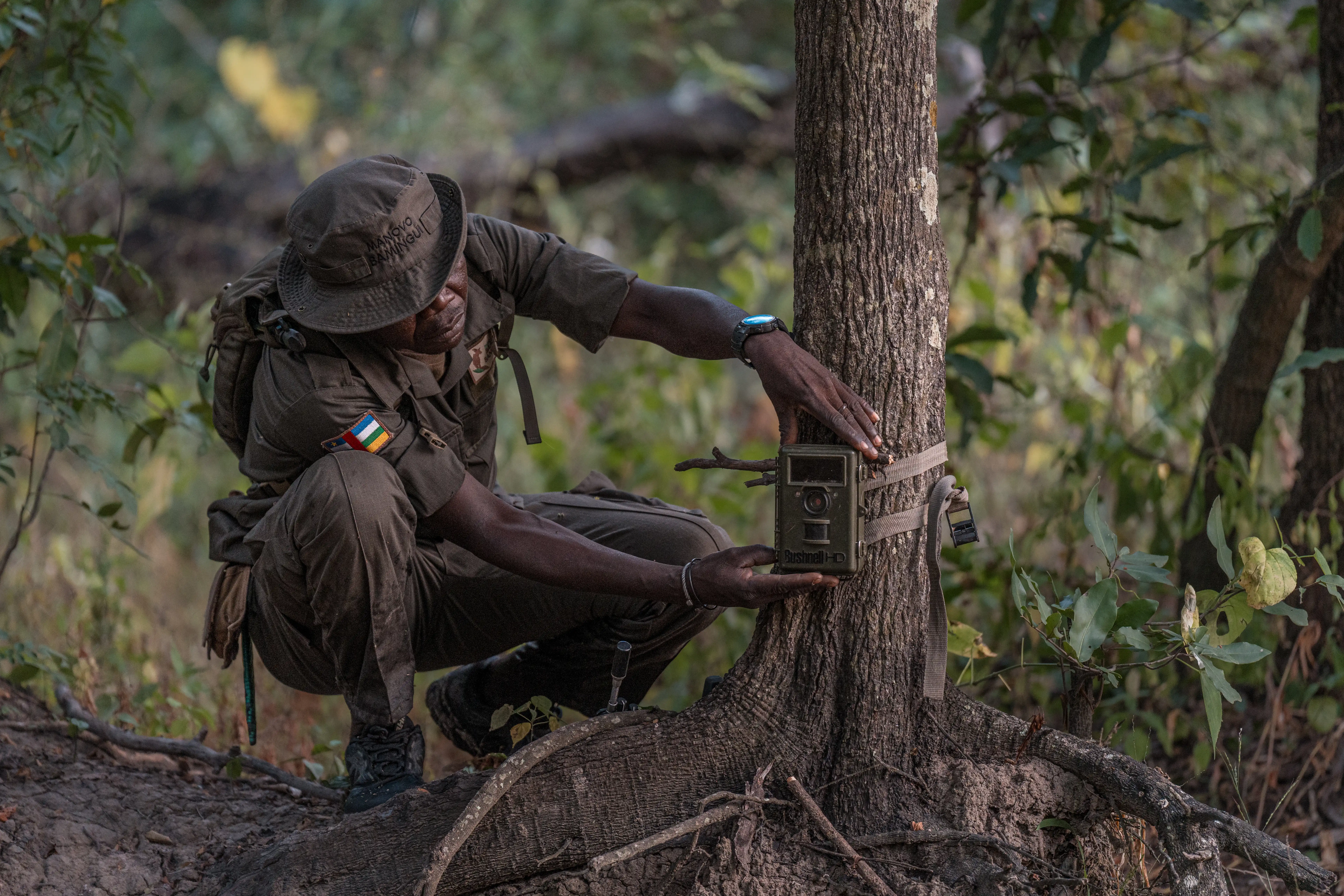
Rangers, 95% from surrounding communities, bring an intimate knowledge of the landscape to protection efforts. Infrastructure is being built to match the mandate: roads, river crossings, renovated airstrips, control rooms to coordinate responses across a landscape larger than Iceland. New park managers with deep field experience are now in place. But the most consequential infrastructure is human.
Every quarter, joint monitoring committees convene across the landscape — elected officials, traditional chiefs, women, youth, church leaders, herders — creating the space where communities shape conservation decisions rather than receive them. Grievance mechanisms in three communities, expanding to more, help resolve conflicts. When a herder disputes a boundary or a farmer loses crops, there is a formal channel. These aren't consultation exercises. They are governance structures, built slowly in partnership with communities who help steward the landscape.
Livelihoods are diversifying — shea butter and honey production, sustainable fishing, tree seedlings replacing wood taken from the forest — practical alternatives co-created with communities who know what pressures are real and what solutions will hold.
Resilience by Design
At the landscape level, micro-zoning is reshaping how the entire 115,000 square kilometers functions.
At the centre: intact wildlife cores where ecosystems can function without disturbance. Around them: corridors where animals move seasonally between protected areas. And beyond that, a vision is taking shape — a wildlife pathway running from Zakouma National Park in Chad, south through this landscape, through Chinko in southeast Central African Republic, to Garamba National Park in the Democratic Republic of Congo.
Further out, zones are designated for seasonal grazing - not banning traditional herding but channeling it, allowing families to follow routes they've used for generations while managing timing and intensity to prevent overgrazing during critical periods. Agricultural areas sit at the outermost rings, positioned to benefit from what healthy forests provide: water regulation, soil stability, and climate moderation, while minimizing conflict with recovering wildlife populations and grazing communities.
Communities aren't just consulted on these zones - they're mapping them. Identifying where water sources matter most, where seasonal patterns dictate land use, and where their needs and wildlife recovery can coexist. The resulting plans become formalized through local governance structures, giving communities legal authority to manage resources in their own territories.
Where the Law Runs Out
But field operations and community governance can only hold so much. The pressures driving illegal herding into the park don't begin at the park boundary — they begin in the absence of functioning policy across three countries. That is where the third front of this work operates.
The legal framework already exists on paper: cattle are supposed to be registered at borders, herders should carry proof of vaccination. But there are no agents to enforce it. No systems. No presence at the remote crossings where the herds come through.
WCS is working with the government to build what the law requires but cannot yet deliver: a transboundary transhumance strategy with the capacity to function in practice, not just on paper. That means coordinating across ministries in Bangui, regional authorities, and representatives from Chad and Sudan. Beyond putting policy on paper, the goal is to help the government extend governance in the region. Supporting the government to deploy border agents. Building systems that can enforce what laws require. Helping extend state capacity to areas historically beyond its reach.
And the transhumance strategy offers a framework for one of the most complex challenges facing the Sahel: how to manage climate-driven migration in ways that sustain both people and ecosystems. If it works here, the model can travel.
Early evidence of progress
The transformation is still in early stages, but a threshold has been crossed. Wildlife is returning to areas where it had vanished. Not in the numbers that existed forty years ago, but returning. Moving back into territories they'd abandoned, reestablishing ranges, breeding.
Bamingui Bangoran National Park, camera traps captured lion cubs – a sign of new life - for the first time in decades—proof that even in extreme fragility, wildlife recovers when resilience holds.
The returning wildlife shows that policy, landscape planning, and community partnership can function together. But this is restoration's beginning.
But it starts here, now, with the first signs of recovery taking root.
Protecting the continental
climate barrier
Across the Sahel, similar transition zones are fragmenting, thinning, and breaking. As they fail, desertification accelerates. The Sahara pushes south in surges, consuming landscapes and displacing populations in cascading waves.
But the forest is still standing. The rivers still run silver through it. The canopy is still intact.
What cannot be seen from above is whether the ecosystem beneath the canopy is undergoing restoration — whether animals are returning, water is being regulated, and the forest is regaining its capacity to function as a climate barrier. That is the work happening now, on the ground, out of sight: rangers building relationships that take years to earn, communities mapping territories their grandchildren will manage, and a government extending governance into territories it could not reach historically.
The importance of this transcends Manovo and Bamingui’s borders. On a much larger scale, it provides proof that the systems regulating our planet’s climate will persist even under the mounting pressures of the 21st century.
The infrastructure being built now is the foundation for decades of restoration. The wildlife returning is the first sign that we have created the conditions.